Yellowstone Park. You’ve probably heard of it. Established on March 1, 1872, it was the first national park in the United States. Some consider it the first national park in the world. It truly is an international tourist destination. This is evidenced by the droves of tourists arriving by the car and busload throughout the park. For this reason, I’ve been hesitant to travel through the park by bicycle. Sharing a road with a designated bike lane doesn’t get a second thought from me. But sharing a narrow road with someone who may not know the park rules, local laws, nor speak the language or be able to read the signs AND being distracted by the geothermal features and wildlife is another. Quite frankly, it wasn’t a risk I was willing to take, no matter how beautiful the scenery.
When I heard that there was an organized ride through the park in the fall, a little spark of hope was lit. Riding a bike in my favorite season, through one of my favorite places, with support and lots of signage alerting drivers of the cyclists was just what I needed!
I did some online research and discovered the website www.cycleyellowstone.com. Registration for the 2016 Yellowstone Cycle Tour would open on June 15, 2016 and close when sold out. The ride was limited to 300 riders. I marked my calendar and began to consider who I would ask to ride with me. The drive to West Yellowstone would be a very long day in the car from Denver, and perhaps best suited for two days. The ride from

Kimberly is the only woman who could pair cycling clothes with cowboy boots and make it look good!
West Yellowstone to Old Faithful was 62 miles round trip. In October, it could be snowing there. Of all my family members and friends, Kimberly was the one person who just might be crazy enough to sign up for this adventure with me… and she did.
We arrived in beautiful West Yellowstone, Montana on the eve of October 7th. Kimberly is a local in Bozeman and was able to score us a very nice room at the Bar N Ranch just outside of West Yellowstone. We had an excellent dinner in the dining hall at the ranch and got up early Saturday morning for breakfast before our departure. The ride was organized to depart in two waves. The first wave was for what the ride organizers referred to as “more experienced riders” and the second wave was for the less experienced. We departed somewhere in the middle between the two waves. We settled into a slight prolonged climb for the next fifteen miles. The buffalo and elk wasted no time and made their appearance very quickly into our ride.

Lots of this type of signage was placed along the ride route.
The only aid station was located fifteen miles into the ride at Madison Junction. We stopped for a bathroom break and visited the very well stocked aid station. Ride organizers had provided an assortment of fresh fruits, candies, packaged bars, and liquids for riders. The departure from Madison Junction was directly into a prolonged climb that leveled out on the top of a plateau about 500 vertical feet later at 7200 feet . It was along this plateau about 7 miles from Old Faithful where the highlight of the trip occurred. Kimberly and I were just riding along when we realized how quiet it had become because there was not another cyclist or car nearby. The only thing nearby were the 20-30 buffalo bedded down maybe 30 feet from the road. This was the closest that I’d ever been to the giants and it was quite magnificent to see. I very much wanted to stop for a picture, but did not want to stop for any wildlife near the road without having a car between us.
When we arrived at Old Faithful, the first order of business was to find the lunch tent. The second order of business was to see whether Old Faithful was erupting or how long we might have to wait until the next predicted eruption. We had about 45 minutes to wait and despite the fact that we’d both seen the eruption before, decided that it was worth the wait after pedaling for 30 miles. We sat down to enjoy the lunch that was an option at registration. Mine consisted of a very tasty PB&J, chips, an apple, and a cookie. There were also other munchies available for riders at the tour tent.
After watching Old Faithful do its magic, we hopped back on the bikes. Kimberly was vocal  about her tushy not being very excited about being back in the saddle. If she had wanted to catch the SAG wagon, she could have because they were plentiful. But like all the Minkoff’s, she didn’t give up. Eventually, we came back to the feed station at Madison Junction and stopped for sweets and coffee. Much to our surprise, we found ourselves removing clothing because the weather was so warm.
On the drive back to Bozeman, we decided that despite our aches and pains, we had a fantastic time. So much so that there is likely to be another cousins adventure next year. Stay tuned!!
PS – Off road biking in Yellowstone is limited to very few (read: short) opportunities. Check their website for details. Spots in the Yellowstone Cycle tour are limited and go fast. We were essentially begged to ride single file to ensure that the event would be a go the following year. If you are the kind of cyclist who is incapable of riding single file, don’t register for this event. Don’t be the person who spoils this wonderful opportunity for others. Just don’t.
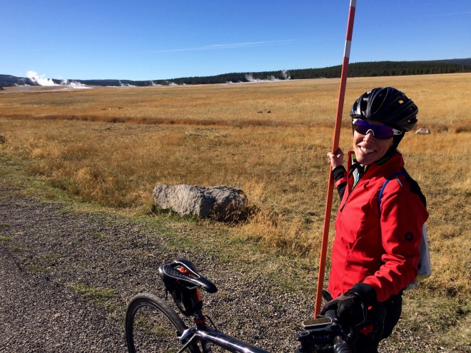
This is the Midway Basin Geyser area. Yep, that’s a snow pole and it’s taller than me!
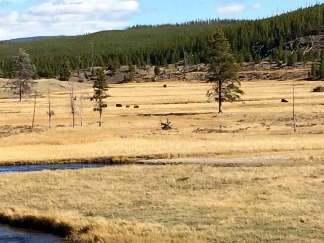
Yep, those are buffalos laying in the meadow. They were far enough away that I was willing to stop for a picture. (Madison Junction area)


